National Register of Historic Places listings in Chatham County, Georgia

This is a list of properties and districts in Chatham County, Georgia that are listed on the National Register of Historic Places (NRHP).
Map all coordinates using OpenStreetMap
Download coordinates as:
- KML
- GPX (all coordinates)
- GPX (primary coordinates)
- GPX (secondary coordinates)
This National Park Service list is complete through NPS recent listings posted June 28, 2024.[1]
- v
- t
- e
Properties on the National Register of Historic Places in Georgia by county
- Appling
- Atkinson
- Bacon
- Baker
- Baldwin
- Banks
- Barrow
- Bartow
- Ben Hill
- Berrien
- Bibb
- Bleckley
- Brantley
- Brooks
- Bryan
- Bulloch
- Burke
- Butts
- Calhoun
- Camden
- Candler
- Carroll
- Catoosa
- Charlton
- Chatham
- Chattahoochee
- Chattooga
- Cherokee
- Clarke
- Clay
- Clayton
- Clinch
- Cobb
- Coffee
- Colquitt
- Columbia
- Cook
- Coweta
- Crawford
- Crisp
- Dade
- Dawson
- Decatur
- DeKalb
- Dodge
- Dooly
- Dougherty
- Douglas
- Early
- Echols
- Effingham
- Elbert
- Emanuel
- Evans
- Fannin
- Fayette
- Floyd
- Forsyth
- Franklin
- Fulton
- Gilmer
- Glascock
- Glynn
- Gordon
- Grady
- Greene
- Gwinnett
- Habersham
- Hall
- Hancock
- Haralson
- Harris
- Hart
- Heard
- Henry
- Houston
- Irwin
- Jackson
- Jasper
- Jeff Davis
- Jefferson
- Jenkins
- Johnson
- Jones
- Lamar
- Lanier
- Laurens
- Lee
- Liberty
- Lincoln
- Long
- Lowndes
- Lumpkin
- Macon
- Madison
- Marion
- McDuffie
- McIntosh
- Meriwether
- Miller
- Mitchell
- Monroe
- Montgomery
- Morgan
- Murray
- Muscogee
- Newton
- Oconee
- Oglethorpe
- Paulding
- Peach
- Pickens
- Pierce
- Pike
- Polk
- Pulaski
- Putnam
- Quitman
- Rabun
- Randolph
- Richmond
- Rockdale
- Schley
- Screven
- Seminole
- Spalding
- Stephens
- Stewart
- Sumter
- Talbot
- Taliaferro
- Tattnall
- Taylor
- Telfair
- Terrell
- Thomas
- Tift
- Toombs
- Towns
- Treutlen
- Troup
- Turner
- Twiggs
- Union
- Upson
- Walker
- Walton
- Ware
- Warren
- Washington
- Wayne
- Webster
- Wheeler
- White
- Whitfield
- Wilcox
- Wilkes
- Wilkinson
- Worth

Current listings
| [2] | Name on the Register | Image | Date listed[3] | Location | City or town | Description |
|---|---|---|---|---|---|---|
| 1 | Edmund and Mildred Abrahams Raised Tybee Cottage |  | January 27, 2020 (#100004900) | 4 Eighth St. 32°00′13″N 80°50′36″W / 32.00355°N 80.84346°W / 32.00355; -80.84346 (Edmund and Mildred Abrahams Raised Tybee Cottage) | Tybee Island | |
| 2 | Ardsley Park-Chatham Crescent Historic District |  | August 15, 1985 (#85001787) | Roughly bounded by Ardsley Pk., Chatham Crescent, Bull St., Baldwin Pk. and Ardmore 32°02′50″N 81°05′42″W / 32.047222°N 81.095°W / 32.047222; -81.095 (Ardsley Park-Chatham Crescent Historic District) | Savannah | |
| 3 | Atlantic Greyhound Bus Terminal |  | December 13, 2016 (#16000837) | 109 Martin Luther King, Jr. Blvd. 32°04′47″N 81°05′51″W / 32.079828°N 81.097621°W / 32.079828; -81.097621 (Atlantic Greyhound Bus Terminal) | Savannah | Now houses The Grey Bar & Restaurant. Proposed nomination form[usurped] Press release[usurped] |
| 4 | Bethesda Home for Boys |  | September 12, 1973 (#73000614) | S of Savannah at Ferguson Ave. and Bethesda Rd. 31°57′34″N 81°05′43″W / 31.95944°N 81.09528°W / 31.95944; -81.09528 (Bethesda Home for Boys) | Savannah | |
| 5 | Bonaventure Cemetery |  | February 2, 2001 (#01000035) | Bonaventure Rd., 1 mi. N of US 80 32°02′38″N 81°02′44″W / 32.043889°N 81.045556°W / 32.043889; -81.045556 (Bonaventure Cemetery) | Savannah | |
| 6 | Bordley Cottage-Beach View House |  | June 27, 2014 (#14000345) | 1701 Butler Ave. 31°59′27″N 80°51′01″W / 31.9909559°N 80.8501883°W / 31.9909559; -80.8501883 (Bordley Cottage-Beach View House) | Tybee Island | |
| 7 | The Carbo House |  | May 21, 2010 (#10000273) | 9 Tybrisa St. 31°59′31″N 80°50′53″W / 31.99189°N 80.84805°W / 31.99189; -80.84805 (The Carbo House) | Tybee Island | Weekly boarding as of 2016 |
| 8 | Carver Village Historic District |  | January 24, 2019 (#100003340) | Bounded by W. Gwinnett & Endley Sts., Allen Blun, & Collat Aves. 32°04′16″N 81°07′35″W / 32.071084°N 81.126509°W / 32.071084; -81.126509 (Carver Village Historic District) | Savannah | |
| 9 | Central of Georgia Depot and Trainshed |  | December 8, 1976 (#76000610) | Martin Luther King Jr Blvd (formerly W. Broad St.) and Liberty Sts. 32°04′34″N 81°05′57″W / 32.07607°N 81.09923°W / 32.07607; -81.09923 (Central of Georgia Depot and Trainshed) | Savannah | Currently the site of the Savannah History Museum |
| 10 | Central of Georgia Railroad: Savannah Shops and Terminal Facilities |  | June 2, 1978 (#78000970) | Martin Luther King Jr Blvd (formerly W. Broad St.) and Railroad Ave. 32°04′33″N 81°06′05″W / 32.07571°N 81.10126°W / 32.07571; -81.10126 (Central of Georgia Railroad: Savannah Shops and Terminal Facilities) | Savannah | A National Historic Landmark and currently the home of the Georgia State Railroad Museum; expansion of the Central of Georgia Depot and Trainshed listing |
| 11 | Central of Georgia Railway Company Shop Property |  | March 5, 1970 (#70000199) | Between W. Jones St. and Louisville Rd. 32°04′37″N 81°05′56″W / 32.07700°N 81.09881°W / 32.07700; -81.09881 (Central of Georgia Railway Company Shop Property) | Savannah | Now Clark Hall of the Savannah College of Art and Design |
| 12 | Charity Hospital |  | May 2, 1985 (#85000934) | 644 W. 36th St. 32°03′37″N 81°06′29″W / 32.060278°N 81.108056°W / 32.060278; -81.108056 (Charity Hospital) | Savannah | Now Heritage Place Apartments |
| 13 | CSS Georgia (ironclad) |  | February 10, 1987 (#86003746) | At the bottom of the Savannah River 32°05′05″N 81°02′09″W / 32.0847°N 81.0358°W / 32.0847; -81.0358 (CSS Georgia (ironclad)) | Savannah | |
| 14 | Cuyler-Brownville Historic District |  | February 13, 1998 (#98000028) | Roughly bounded by Anderson Ln., W. 31st St., Montgomery St., Victory Dr., Ogeechee Rd., and Hopkins St. 32°03′30″N 81°06′29″W / 32.058333°N 81.108056°W / 32.058333; -81.108056 (Cuyler-Brownville Historic District) | Savannah | |
| 15 | Daffin Park-Parkside Place Historic District |  | May 12, 1999 (#99000554) | Bounded by Victory Dr., Waters Ave., Bee St. and 51st Street Ln. 32°02′37″N 81°04′55″W / 32.043611°N 81.081944°W / 32.043611; -81.081944 (Daffin Park-Parkside Place Historic District) | Savannah | |
| 16 | Isaiah Davenport House |  | September 22, 1972 (#72000374) | 324 E. State St. 32°04′38″N 81°05′18″W / 32.077222°N 81.088333°W / 32.077222; -81.088333 (Isaiah Davenport House) | Savannah | |
| 17 | Drayton Tower | 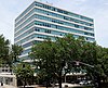 | October 16, 2013 (#13000826) | 102 E. Liberty St. 32°04′29″N 81°05′31″W / 32.074607°N 81.091956°W / 32.074607; -81.091956 (Drayton Tower) | Savannah | Originally named the Drayton Arms Apartments |
| 18 | Drouillard-Maupas House |  | May 13, 1991 (#91000558) | 2422 Abercorn St. 32°03′11″N 81°05′56″W / 32.053056°N 81.098889°W / 32.053056; -81.098889 (Drouillard-Maupas House) | Savannah | |
| 19 | Dutton-Waller Raised Tybee Cottage | 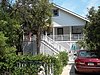 | July 24, 2008 (#08000711) | 1416 7th Ave. 31°59′44″N 80°51′13″W / 31.995692°N 80.853719°W / 31.995692; -80.853719 (Dutton-Waller Raised Tybee Cottage) | Tybee Island | |
| 20 | Eastside Historic District | 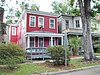 | November 7, 2002 (#02001292) | Roughly bounded by E. Broad (now MLK Blvd), Cedar, Gwinnett and Anderson Sts. 32°03′36″N 81°05′03″W / 32.06°N 81.084167°W / 32.06; -81.084167 (Eastside Historic District) | Savannah | |
| 21 | Eureka Club-Farr's Point | 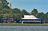 | July 8, 2009 (#09000491) | 2326 East Blvd. on Wilmington Island 31°58′18″N 81°00′01″W / 31.97180°N 81.00015°W / 31.97180; -81.00015 (Eureka Club-Farr's Point) | Savannah | |
| 22 | Fairway Oaks-Greenview Historic District |  | March 31, 2009 (#09000184) | Bounded approximately by DeRenne Drive, Waters Avenue, Truman Parkway, and Casey Canal, and the Live Oaks Golf Course 32°01′15″N 81°05′31″W / 32.020711°N 81.092058°W / 32.020711; -81.092058 (Fairway Oaks-Greenview Historic District) | Savannah | |
| 23 | Federal Building and U.S. Courthouse | 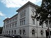 | June 7, 1974 (#74000663) | Wright Sq. 32°04′41″N 81°05′35″W / 32.078056°N 81.093056°W / 32.078056; -81.093056 (Federal Building and U.S. Courthouse) | Savannah | |
| 24 | First Bryan Baptist Church |  | May 22, 1978 (#78000971) | 575 W. Bryan St. 32°04′55″N 81°05′57″W / 32.08208°N 81.09906°W / 32.08208; -81.09906 (First Bryan Baptist Church) | Savannah | |
| 25 | Fort James Jackson | 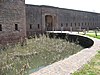 | February 18, 1970 (#70000200) | Islands Expwy. 32°04′55″N 81°02′10″W / 32.081944°N 81.036111°W / 32.081944; -81.036111 (Fort James Jackson) | Savannah | National Historic Landmark |
| 26 | Fort Pulaski National Monument | 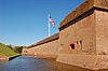 | October 15, 1966 (#66000064) | 17 mi. W of Savannah, Cockspur Island 32°01′41″N 80°53′50″W / 32.028056°N 80.897222°W / 32.028056; -80.897222 (Fort Pulaski National Monument) | Savannah | administered by the National Park Service |
| 27 | Fort Screven Historic District |  | May 25, 1982 (#82002393) | Tilton, Butler, Van Horn, Railroad and Alger Aves., and Pulaski Rd. 32°01′24″N 80°51′00″W / 32.023333°N 80.85°W / 32.023333; -80.85 (Fort Screven Historic District) | Tybee Island | |
| 28 | Gordonston Historic District |  | October 11, 2001 (#01000741) | Roughly bounded by Skidaway Rd., Goebel Ave., Gwinnett St., and Pennsylvania Ave. 32°03′17″N 81°03′47″W / 32.054722°N 81.063056°W / 32.054722; -81.063056 (Gordonston Historic District) | Savannah | |
| 29 | Green-Meldrim House |  | January 21, 1974 (#74000664) | Macon and Bull Sts. 32°04′26″N 81°05′41″W / 32.073889°N 81.094722°W / 32.073889; -81.094722 (Green-Meldrim House) | Savannah | National Historic Landmark |
| 30 | Hill Hall at Savannah State College |  | April 23, 1981 (#81000197) | Savannah State College campus 32°01′27″N 81°03′23″W / 32.024053°N 81.056475°W / 32.024053; -81.056475 (Hill Hall at Savannah State College) | Savannah | |
| 31 | W. B. Hodgson Hall | 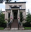 | March 25, 1977 (#77000413) | 501 Whitaker St. 32°04′13″N 81°05′49″W / 32.070278°N 81.096944°W / 32.070278; -81.096944 (W. B. Hodgson Hall) | Savannah | |
| 32 | Isle of Hope Historic District |  | September 7, 1984 (#84003874) | Roughly bounded by Skidaway River, Parkersburg Rd., Island, Cornus, and Noble Glen Drs. 31°58′49″N 81°03′21″W / 31.980278°N 81.055833°W / 31.980278; -81.055833 (Isle of Hope Historic District) | Savannah | |
| 33 | J. Herbert and Julia Johnson Raised Tybee Cottage |  | May 21, 2008 (#08000441) | 1306 Jones Ave. 31°59′48″N 80°50′58″W / 31.996703°N 80.849564°W / 31.996703; -80.849564 (J. Herbert and Julia Johnson Raised Tybee Cottage) | Tybee Island | |
| 34 | Kensington Park-Groveland Historic District |  | August 30, 2014 (#14000533) | Roughly bounded by DeRenne & Waters Aves., Abercorn & Johnston Sts. 32°01′24″N 81°06′12″W / 32.0233°N 81.1033°W / 32.0233; -81.1033 (Kensington Park-Groveland Historic District) | Savannah[4] | |
| 35 | Laurel Grove-North Cemetery |  | August 4, 1983 (#83000187) | W. Anderson St. 32°03′53″N 81°06′31″W / 32.064722°N 81.108611°W / 32.064722; -81.108611 (Laurel Grove-North Cemetery) | Savannah | |
| 36 | Laurel Grove-South Cemetery |  | September 6, 1978 (#78000972) | 37th St. 32°03′37″N 81°06′57″W / 32.060278°N 81.115833°W / 32.060278; -81.115833 (Laurel Grove-South Cemetery) | Savannah | |
| 37 | Lebanon Plantation |  | November 29, 1979 (#79000704) | SW of Savannah 32°00′22″N 81°12′38″W / 32.006°N 81.2105°W / 32.006; -81.2105 (Lebanon Plantation) | Savannah | Private property, gated |
| 38 | Juliette Gordon Low Historic District |  | October 15, 1966 (#66000276) | 10 Oglethorpe Ave., E., 330 Drayton St., 329 Abercorn St. 32°04′37″N 81°05′33″W / 32.077062°N 81.092480°W / 32.077062; -81.092480 (Juliette Gordon Low Historic District) | Savannah | National Historic Landmark, The district consists of three buildings associated with the origins of the Girl Scouts of the USA, the "Juliette Gordon Low Birthplace," the "Andrew Low House," and the "Andrew Low Carriage House". |
| 39 | Massie Common School House |  | April 13, 1977 (#77000414) | 207 E. Gordon St. 32°04′13″N 81°05′33″W / 32.07020°N 81.09245°W / 32.07020; -81.09245 (Massie Common School House) | Savannah | |
| 40 | Morgan-Ille Cottage |  | July 24, 2008 (#08000713) | 703 2nd Ave. 32°00′19″N 80°50′44″W / 32.005211°N 80.845625°W / 32.005211; -80.845625 (Morgan-Ille Cottage) | Tybee Island | |
| 41 | Mulberry Grove Site | Upload image | July 17, 1975 (#75000575) | Address Restricted (305 S Coastal Hwy) 32°11′N 81°10′W / 32.19°N 81.16°W / 32.19; -81.16 (Mulberry Grove Site) | Port Wentworth | Left in ruins, reportedly only a marker was left and it is missing[5] |
| 42 | Mulherin-Righton Raised Tybee Cottage |  | April 29, 2008 (#08000349) | 14 8th Pl. 32°00′10″N 80°50′39″W / 32.002778°N 80.844244°W / 32.002778; -80.844244 (Mulherin-Righton Raised Tybee Cottage) | Tybee Island | |
| 43 | New Ogeechee Missionary Baptist Church |  | August 8, 2001 (#01000854) | 751 Chevis Rd. 31°58′40″N 81°14′57″W / 31.977778°N 81.249167°W / 31.977778; -81.249167 (New Ogeechee Missionary Baptist Church) | Savannah | |
| 44 | Nicholsonville Baptist Church |  | May 22, 1978 (#78000969) | White Bluff Rd. 31°57′30″N 81°08′18″W / 31.958333°N 81.138333°W / 31.958333; -81.138333 (Nicholsonville Baptist Church) | Nicholsonville | |
| 45 | Ossabaw Island | Upload image | May 6, 1996 (#96000468) | 7 mi. S of Savannah, bounded by the Atlantic Ocean, Bear R., Ogeechee R., and St. Catherine's Sound 31°47′40″N 81°06′44″W / 31.794444°N 81.112222°W / 31.794444; -81.112222 (Ossabaw Island) | Savannah | |
| 46 | Owens-Thomas House |  | May 11, 1976 (#76000611) | 124 Abercorn St. 32°04′39″N 81°05′22″W / 32.07738°N 81.08940°W / 32.07738; -81.08940 (Owens-Thomas House) | Savannah | National Historic Landmark |
| 47 | Pine Gardens Historic District |  | November 5, 2014 (#14000890) | Roughly bounded by Goebel Ave., Beech & Capitol Sts. 32°04′00″N 81°03′23″W / 32.0666°N 81.0565°W / 32.0666; -81.0565 (Pine Gardens Historic District) | Savannah | |
| 48 | James and Odessa Rourke, Jr., Raised Tybee Cottage | 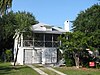 | September 23, 2010 (#10000804) | 702 14th St. 31°59′49″N 80°51′10″W / 31.996944°N 80.852778°W / 31.996944; -80.852778 (James and Odessa Rourke, Jr., Raised Tybee Cottage) | Tybee Island | |
| 49 | St. Bartholomew's Church | 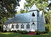 | June 17, 1982 (#82002391) | Chevis Rd. 31°58′13″N 81°14′42″W / 31.970278°N 81.245°W / 31.970278; -81.245 (St. Bartholomew's Church) | Burroughs | |
| 50 | St. Philip AME Church |  | August 2, 1984 (#84000959) | 613 Martin Luther King Jr Blvd (formerly W. Broad St.) 32°04′13″N 81°06′05″W / 32.070278°N 81.101389°W / 32.070278; -81.101389 (St. Philip AME Church) | Savannah | |
| 51 | Savannah and Ogeechee Canal |  | August 11, 1997 (#97000814) | Roughly along I-95, between the Savannah and Ogeechee Rivers 32°03′40″N 81°13′18″W / 32.06112°N 81.22157°W / 32.06112; -81.22157 (Savannah and Ogeechee Canal) | Chatham | |
| 52 | Savannah Beach Town Hall and Auditorium |  | May 27, 2022 (#100007755) | 403 Butler Ave. 32°00′31″N 80°50′35″W / 32.00869°N 80.84300°W / 32.00869; -80.84300 (Savannah Beach Town Hall and Auditorium) | Tybee Island | |
| 53 | Savannah Historic District |  | November 13, 1966 (#66000277) | Bounded by E. Broad, Gwinnett, and W. Broad Sts. and the Savannah River (Broad St. is now MLK Blvd) 32°04′28″N 81°05′30″W / 32.074444°N 81.091667°W / 32.074444; -81.091667 (Savannah Historic District) | Savannah | National Historic Landmark |
| 54 | Savannah Pharmacy and Fonvielle Office Building | Upload image | February 20, 2013 (#13000023) | 914-918 Martin Luther King, Jr. Blvd. 32°04′02″N 81°06′08″W / 32.067262°N 81.102112°W / 32.067262; -81.102112 (Savannah Pharmacy and Fonvielle Office Building) | Savannah | Demolished in 2014[6] NPS |
| 55 | Savannah Victorian Historic District | 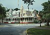 | December 11, 1974 (#74000665) | Roughly bounded by Gwinnett, Price, Anderson, and Montgomery Sts.; also the area bounded by Gwinnett, Anderson and 31st Sts. 32°03′53″N 81°05′49″W / 32.064722°N 81.096944°W / 32.064722; -81.096944 (Savannah Victorian Historic District) | Savannah | Second set of boundaries represents a boundary increase of May 20, 1982 (refnum 82002392) |
| 56 | Savannah Water Works Pump House | 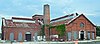 | January 24, 2022 (#100007368) | 1204 West Gwinnett St. 32°04′18″N 81°06′49″W / 32.0717°N 81.1137°W / 32.0717; -81.1137 (Savannah Water Works Pump House) | Savannah | |
| 57 | William Scarbrough House |  | June 22, 1970 (#70000201) | 41 Martin Luther King Jr Blvd (formerly W. Broad St.) 32°04′52″N 81°05′50″W / 32.08117°N 81.09727°W / 32.08117; -81.09727 (William Scarbrough House) | Savannah | National Historic Landmark, now houses the Ships of the Sea Maritime Museum |
| 58 | Sea View Apartments |  | April 22, 2003 (#03000286) | 7 18th St. 31°59′21″N 80°50′57″W / 31.98909°N 80.84930°W / 31.98909; -80.84930 (Sea View Apartments) | Tybee Island | |
| 59 | Slotin Building |  | March 24, 1983 (#83000188) | 101 Martin Luther King Jr Blvd (formerly W. Broad St.) 32°04′48″N 81°05′52″W / 32.08007°N 81.09766°W / 32.08007; -81.09766 (Slotin Building) | Savannah | Now Bergen Hall of the Savannah College of Art and Design |
| 60 | Springfield Terrace School |  | March 9, 2022 (#100007479) | 707 Hastings St. 32°04′24″N 81°06′57″W / 32.0732°N 81.1157°W / 32.0732; -81.1157 (Springfield Terrace School) | Savannah | |
| 61 | Oliver Sturges House |  | July 14, 1971 (#71000271) | 27 Abercorn St. 32°04′45″N 81°05′24″W / 32.079167°N 81.09°W / 32.079167; -81.09 (Oliver Sturges House) | Savannah | |
| 62 | Telfair Academy |  | May 11, 1976 (#76000612) | 121 Barnard St. 32°04′44″N 81°05′43″W / 32.078889°N 81.095278°W / 32.078889; -81.095278 (Telfair Academy) | Savannah | National Historic Landmark |
| 63 | Thomas Square Streetcar Historic District |  | July 29, 1997 (#97000813) | Roughly bounded by Anderson Ln., 42nd St., Victory Dr., E. Broad St., and Martin Luther King, Jr. Blvd. 32°03′28″N 81°05′56″W / 32.057778°N 81.098889°W / 32.057778; -81.098889 (Thomas Square Streetcar Historic District) | Savannah | |
| 64 | Two Pierpont Circle |  | April 4, 1990 (#90000492) | 2 Pierpont Cir. 32°03′17″N 81°04′01″W / 32.054722°N 81.066944°W / 32.054722; -81.066944 (Two Pierpont Circle) | Savannah | |
| 65 | Tybee Island Back River Historic District |  | August 5, 1999 (#99000928) | Along Chatham Ave., from Tybee River to Venetian Dr. 31°59′27″N 80°51′09″W / 31.990833°N 80.8525°W / 31.990833; -80.8525 (Tybee Island Back River Historic District) | Tybee Island | |
| 66 | Tybee Island Strand Cottages Historic District |  | April 2, 1999 (#98000971) | Selected properties between Butler Ave. and Atlantic Ocean, between 12 St. and 14th St. 31°59′47″N 80°50′49″W / 31.996389°N 80.846944°W / 31.996389; -80.846944 (Tybee Island Strand Cottages Historic District) | Tybee Island | |
| 67 | U.S. Customhouse |  | May 29, 1974 (#74000666) | 1-3 E. Bay St. 32°04′50″N 81°05′28″W / 32.08065°N 81.09101°W / 32.08065; -81.09101 (U.S. Customhouse) | Savannah | |
| 68 | Vernonburg Historic District |  | June 22, 2000 (#00000714) | Dancy Ave., Rockwell Ave. and S. Rockwell Ave. 31°58′19″N 81°07′34″W / 31.971944°N 81.126111°W / 31.971944; -81.126111 (Vernonburg Historic District) | Vernonburg | |
| 69 | Edgar A. Weil House |  | October 4, 2016 (#16000686) | 802 14th St. 31°59′49″N 80°51′14″W / 31.997010°N 80.853959°W / 31.997010; -80.853959 (Edgar A. Weil House) | Tybee Island | |
| 70 | Wild Heron |  | December 16, 1977 (#77000415) | 15 mi. SW of Savannah off U.S. 17; 2148 Grove Point Rd. 31°58′14″N 81°13′08″W / 31.970556°N 81.218889°W / 31.970556; -81.218889 (Wild Heron) | Savannah | |
| 71 | Clarence and Louise Golden Williams House | Upload image | May 15, 2023 (#100007895) | 2211 Norwood Ave, Sandfly Community 31°59′16″N 81°04′18″W / 31.9879°N 81.0718°W / 31.9879; -81.0718 (Clarence and Louise Golden Williams House) | Savannah | |
| 72 | Wormsloe Plantation |  | April 26, 1973 (#73000615) | Isle of Hope and Long Island 31°57′53″N 81°04′14″W / 31.964722°N 81.070556°W / 31.964722; -81.070556 (Wormsloe Plantation) | Savannah | Now a Georgia state historic site |
References
- ^ National Park Service, United States Department of the Interior, "National Register of Historic Places: Weekly List Actions", retrieved June 28, 2024.
- ^ Numbers represent an alphabetical ordering by significant words. Various colorings, defined here, differentiate National Historic Landmarks and historic districts from other NRHP buildings, structures, sites or objects.
- ^ The eight-digit number below each date is the number assigned to each location in the National Register Information System database, which can be viewed by clicking the number.
- ^ Kensington Park, Groveland gain historic status, by Eric Curl, Savannah Morning News, September 23, 2013
- ^ "Mulberry Grove Marker - Historic Markers Across Georgia". Retrieved March 9, 2017.
- ^ Curl, Eric. "Historic MLK pharmacy demolition begins". Savannah Morning News. July 30, 2014. Retrieved 2015-01-25.
Wikimedia Commons has media related to National Register of Historic Places in Chatham County, Georgia.


