National Register of Historic Places listings in Richmond County, Georgia

This is a list of properties and districts in Richmond County, Georgia that are listed on the National Register of Historic Places (NRHP).
Augusta-Richmond was formed by merger of the independent city of Augusta, Georgia and Richmond County, Georgia.
Map all coordinates using OpenStreetMap
Download coordinates as:
- KML
- GPX (all coordinates)
- GPX (primary coordinates)
- GPX (secondary coordinates)
This National Park Service list is complete through NPS recent listings posted June 28, 2024.[1]
- v
- t
- e
Properties on the National Register of Historic Places in Georgia by county
- Appling
- Atkinson
- Bacon
- Baker
- Baldwin
- Banks
- Barrow
- Bartow
- Ben Hill
- Berrien
- Bibb
- Bleckley
- Brantley
- Brooks
- Bryan
- Bulloch
- Burke
- Butts
- Calhoun
- Camden
- Candler
- Carroll
- Catoosa
- Charlton
- Chatham
- Chattahoochee
- Chattooga
- Cherokee
- Clarke
- Clay
- Clayton
- Clinch
- Cobb
- Coffee
- Colquitt
- Columbia
- Cook
- Coweta
- Crawford
- Crisp
- Dade
- Dawson
- Decatur
- DeKalb
- Dodge
- Dooly
- Dougherty
- Douglas
- Early
- Echols
- Effingham
- Elbert
- Emanuel
- Evans
- Fannin
- Fayette
- Floyd
- Forsyth
- Franklin
- Fulton
- Gilmer
- Glascock
- Glynn
- Gordon
- Grady
- Greene
- Gwinnett
- Habersham
- Hall
- Hancock
- Haralson
- Harris
- Hart
- Heard
- Henry
- Houston
- Irwin
- Jackson
- Jasper
- Jeff Davis
- Jefferson
- Jenkins
- Johnson
- Jones
- Lamar
- Lanier
- Laurens
- Lee
- Liberty
- Lincoln
- Long
- Lowndes
- Lumpkin
- Macon
- Madison
- Marion
- McDuffie
- McIntosh
- Meriwether
- Miller
- Mitchell
- Monroe
- Montgomery
- Morgan
- Murray
- Muscogee
- Newton
- Oconee
- Oglethorpe
- Paulding
- Peach
- Pickens
- Pierce
- Pike
- Polk
- Pulaski
- Putnam
- Quitman
- Rabun
- Randolph
- Richmond
- Rockdale
- Schley
- Screven
- Seminole
- Spalding
- Stephens
- Stewart
- Sumter
- Talbot
- Taliaferro
- Tattnall
- Taylor
- Telfair
- Terrell
- Thomas
- Tift
- Toombs
- Towns
- Treutlen
- Troup
- Turner
- Twiggs
- Union
- Upson
- Walker
- Walton
- Ware
- Warren
- Washington
- Wayne
- Webster
- Wheeler
- White
- Whitfield
- Wilcox
- Wilkes
- Wilkinson
- Worth

Current listings
| [2] | Name on the Register | Image | Date listed[3] | Location | City or town | Description |
|---|---|---|---|---|---|---|
| 1 | Academy of Richmond County |  | April 11, 1973 (#73000639) | 540 Telfair St. 33°28′12″N 81°57′45″W / 33.47°N 81.9625°W / 33.47; -81.9625 (Academy of Richmond County) | Augusta | |
| 2 | Academy of Richmond County-1926 Campus |  | January 28, 2004 (#03001491) | 910 Russell St. 33°28′25″N 82°00′17″W / 33.473611°N 82.004722°W / 33.473611; -82.004722 (Academy of Richmond County-1926 Campus) | Augusta | |
| 3 | Augusta Canal Industrial District |  | May 27, 1971 (#71000285) | Along the west bank of the Savannah River from the Richmond-Columbia county line to 10th and Fenwick Sts. 33°29′51″N 81°59′47″W / 33.4975°N 81.996389°W / 33.4975; -81.996389 (Augusta Canal Industrial District) | Augusta | National Historic Landmark (canal and historic district), extends into Columbia County |
| 4 | Augusta Cotton Exchange Building | 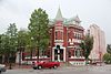 | July 20, 1978 (#78001003) | Reynolds St. 33°28′35″N 81°57′53″W / 33.476389°N 81.964722°W / 33.476389; -81.964722 (Augusta Cotton Exchange Building) | Augusta | |
| 5 | Augusta Downtown Historic District |  | June 11, 2004 (#04000515) | Roughly bounded by 13th St., Gordon Hwy., Walton Way and the Savannah R. 33°28′18″N 81°57′50″W / 33.471667°N 81.963889°W / 33.471667; -81.963889 (Augusta Downtown Historic District) | Augusta | |
| 6 | Augusta Warehouse and Compress Company | Upload image | March 4, 2024 (#100010016) | 1812 Slaton Street 33°27′44″N 82°00′12″W / 33.4622°N 82.0033°W / 33.4622; -82.0033 (Augusta Warehouse and Compress Company) | Augusta | |
| 7 | Bath Presbyterian Church and Cemetery |  | October 27, 2004 (#04001179) | Edie Bath Rd., 0.5 miles (0.80 km) west of US Route 1 33°20′11″N 82°10′22″W / 33.33641°N 82.1728°W / 33.33641; -82.1728 (Bath Presbyterian Church and Cemetery) | Blythe | |
| 8 | Stephen Vincent Benet House | 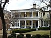 | November 11, 1971 (#71000286) | 2500 Walton Way 33°28′33″N 82°01′27″W / 33.47580°N 82.02407°W / 33.47580; -82.02407 (Stephen Vincent Benet House) | Augusta | National Historic Landmark |
| 9 | Bethlehem Historic District |  | December 1, 1997 (#97001470) | Roughly bounded by Wrightsboro Rd., MLK Jr. Blvd., Railroad, Poplar, and Clay Sts. 33°27′32″N 81°59′05″W / 33.458889°N 81.984722°W / 33.458889; -81.984722 (Bethlehem Historic District) | Augusta | |
| 10 | Brahe House |  | April 11, 1973 (#73000640) | 456 Telfair St. 33°28′09″N 81°57′37″W / 33.469167°N 81.960278°W / 33.469167; -81.960278 (Brahe House) | Augusta | |
| 11 | Broad Street Historic District |  | April 28, 1980 (#80001226) | Broad St. between 5th and 13th Sts. 33°28′30″N 81°58′02″W / 33.475°N 81.967222°W / 33.475; -81.967222 (Broad Street Historic District) | Augusta | |
| 12 | Cauley-Wheeler Memorial Building | Upload image | June 4, 2008 (#08000493) | 1339 Laney Walker Blvd. 33°28′01″N 81°58′58″W / 33.46698°N 81.98274°W / 33.46698; -81.98274 (Cauley-Wheeler Memorial Building) | Augusta | Demolished in 2011[4][5] |
| 13 | Church of the Most Holy Trinity |  | March 21, 1997 (#97000250) | 720 Telfair St. 33°28′18″N 81°58′01″W / 33.471667°N 81.966944°W / 33.471667; -81.966944 (Church of the Most Holy Trinity) | Augusta | |
| 14 | College Hill |  | November 11, 1971 (#71000287) | 2216 Wrightsboro Rd. 33°28′00″N 82°00′48″W / 33.46678°N 82.01322°W / 33.46678; -82.01322 (College Hill) | Augusta | National Historic Landmark |
| 15 | Joseph Darling House | 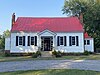 | April 18, 1991 (#91000479) | 3066 Dennis Rd. 33°31′41″N 82°02′55″W / 33.528°N 82.04871°W / 33.528; -82.04871 (Joseph Darling House) | Martinez | |
| 16 | Engine Company Number One |  | May 25, 1988 (#88000565) | 452 Ellis St. 33°28′17″N 81°57′34″W / 33.471389°N 81.959444°W / 33.471389; -81.959444 (Engine Company Number One) | Augusta | |
| 17 | First Baptist Church of Augusta |  | March 23, 1972 (#72000397) | Greene and 8th Sts. 33°28′21″N 81°58′03″W / 33.4725°N 81.9675°W / 33.4725; -81.9675 (First Baptist Church of Augusta) | Augusta | |
| 18 | First Presbyterian Church of Augusta |  | February 21, 1997 (#97000100) | 642 Telfair St. 33°28′13″N 81°57′54″W / 33.470278°N 81.965°W / 33.470278; -81.965 (First Presbyterian Church of Augusta) | Augusta | |
| 19 | FitzSimons-Hampton House |  | October 29, 1976 (#76000645) | SR 28 33°26′59″N 81°55′17″W / 33.449722°N 81.921389°W / 33.449722; -81.921389 (FitzSimons-Hampton House) | Augusta | |
| 20 | Fruitlands |  | May 25, 1979 (#79000742) | 2604 Washington Rd. 33°30′03″N 82°01′20″W / 33.500833°N 82.022222°W / 33.500833; -82.022222 (Fruitlands) | Augusta | Clubhouse of the Augusta National Golf Club - admission only to members and ticket holders to tournaments[6] |
| 21 | Gertrude Herbert Art Institute |  | March 20, 1973 (#73000641) | 506 Telfair St. 33°28′11″N 81°57′41″W / 33.469722°N 81.961389°W / 33.469722; -81.961389 (Gertrude Herbert Art Institute) | Augusta | |
| 22 | Gould-Weed House |  | July 16, 1979 (#79000743) | 828 Milledge Rd. 33°28′35″N 82°00′46″W / 33.476389°N 82.012778°W / 33.476389; -82.012778 (Gould-Weed House) | Augusta | |
| 23 | Greene Street Historic District |  | December 3, 1980 (#80001227) | Greene St. 33°28′25″N 81°58′05″W / 33.473611°N 81.968056°W / 33.473611; -81.968056 (Greene Street Historic District) | Augusta | |
| 24 | Harris-Pearson-Walker House |  | October 28, 1969 (#69000052) | 1822 Broad St. 33°29′04″N 81°59′42″W / 33.484444°N 81.995°W / 33.484444; -81.995 (Harris-Pearson-Walker House) | Augusta | |
| 25 | Harrisburg-West End Historic District |  | June 7, 1990 (#90000802) | Roughly bounded by 15th St., Walton Way, Heard Ave., Milledge Rd., and the Augusta Canal 33°28′55″N 81°59′50″W / 33.481944°N 81.997222°W / 33.481944; -81.997222 (Harrisburg-West End Historic District) | Augusta | |
| 26 | Dr. Asbury and Martha Hull House |  | September 18, 2018 (#100002961) | 2749 Hillcrest Ave. 33°28′40″N 82°01′59″W / 33.4777°N 82.0330°W / 33.4777; -82.0330 (Dr. Asbury and Martha Hull House) | Augusta | |
| 27 | Lamar Building |  | April 24, 1979 (#79000744) | 753 Broad St. 33°28′31″N 81°57′54″W / 33.475278°N 81.965°W / 33.475278; -81.965 (Lamar Building) | Augusta | |
| 28 | Joseph Rucker Lamar Boyhood Home |  | June 13, 1996 (#96000598) | 415 7th St. 33°28′19″N 81°57′55″W / 33.471944°N 81.965278°W / 33.471944; -81.965278 (Joseph Rucker Lamar Boyhood Home) | Augusta | |
| 29 | Laney-Walker North Historic District |  | September 5, 1985 (#85001976) | Bounded by D'Antignac, 7th, Twiggs, Phillips and Harrison Sts., Walton Way and Laney Walker Blvd. 33°28′01″N 81°58′29″W / 33.466944°N 81.974722°W / 33.466944; -81.974722 (Laney-Walker North Historic District) | Augusta | |
| 30 | Liberty Methodist Church |  | November 7, 1997 (#97001330) | 2040 Liberty Church Rd. 33°19′12″N 82°02′17″W / 33.32°N 82.038056°W / 33.32; -82.038056 (Liberty Methodist Church) | Hephzibah | |
| 31 | Meadow Garden |  | July 19, 1976 (#76000646) | 1230 Nelson St. 33°28′26″N 81°58′47″W / 33.47376°N 81.97979°W / 33.47376; -81.97979 (Meadow Garden) | Augusta | Home of George Walton, youngest signer of the U.S. Declaration of Independence, a National Historic Landmark |
| 32 | Neuropsychiatric Infirmary – Building 76 | Upload image | December 7, 2020 (#100005884) | 1798 Maryland Ave., Charlie Norwood VA Medical Center 33°27′58″N 82°01′45″W / 33.4660°N 82.0291°W / 33.4660; -82.0291 (Neuropsychiatric Infirmary – Building 76) | Augusta | |
| 33 | Neuropsychiatric Tuberculosis Ward-Building 7 | Upload image | December 7, 2020 (#100005883) | 1900 Maryland Ave., Charlie Norwood VA Medical Center 33°27′51″N 82°01′46″W / 33.4643°N 82.0295°W / 33.4643; -82.0295 (Neuropsychiatric Tuberculosis Ward-Building 7) | Augusta | |
| 34 | Old Medical College Building |  | March 16, 1972 (#72000398) | Telfair and 6th Sts. 33°28′13″N 81°57′47″W / 33.470278°N 81.963056°W / 33.470278; -81.963056 (Old Medical College Building) | Augusta | National Historic Landmark |
| 35 | Old Richmond County Courthouse |  | December 22, 1978 (#78001004) | 432 Telfair St. 33°28′09″N 81°57′34″W / 33.469167°N 81.959444°W / 33.469167; -81.959444 (Old Richmond County Courthouse) | Augusta | |
| 36 | Paine College Historic District | Upload image | December 26, 2012 (#12001082) | 1235 15th St. 33°28′10″N 81°59′35″W / 33.46954°N 81.993155°W / 33.46954; -81.993155 (Paine College Historic District) | Augusta | [7] |
| 37 | Pinched Gut Historic District |  | March 6, 1980 (#80001228) | Roughly bounded by Gordon Hwy., E. Boundary, Reynolds, and Gwinnett Sts. 33°27′47″N 81°57′22″W / 33.463056°N 81.956111°W / 33.463056; -81.956111 (Pinched Gut Historic District) | Augusta | |
| 38 | Reid-Jones-Carpenter House |  | November 13, 1979 (#79000745) | 2249 Walton Way 33°28′41″N 82°00′56″W / 33.478056°N 82.015556°W / 33.478056; -82.015556 (Reid-Jones-Carpenter House) | Augusta | |
| 39 | Sacred Heart Catholic Church | | March 16, 1972 (#72000399) | Greene and 13th Sts. 33°28′38″N 81°58′37″W / 33.477222°N 81.976944°W / 33.477222; -81.976944 (Sacred Heart Catholic Church) | Augusta | |
| 40 | Sand Hills Historic District |  | July 9, 1997 (#97000754) | Roughly bounded by Monte Sano and North View Aves., Mount Auburn St., Johns Rd., and the Augusta Country Club. 33°29′00″N 82°01′13″W / 33.483333°N 82.020278°W / 33.483333; -82.020278 (Sand Hills Historic District) | Augusta | Historic African-American neighborhood |
| 41 | Seclusaval and Windsor Spring |  | October 11, 1988 (#87001331) | Junction of Windsor Spring and Tobacco Rds. 33°23′05″N 82°04′21″W / 33.384722°N 82.0725°W / 33.384722; -82.0725 (Seclusaval and Windsor Spring) | Hephzibah | |
| 42 | Shiloh Orphanage |  | December 30, 1996 (#96001500) | 1635 15th St. 33°27′32″N 81°59′55″W / 33.458889°N 81.998611°W / 33.458889; -81.998611 (Shiloh Orphanage) | Augusta | |
| 43 | Springfield Baptist Church |  | June 17, 1982 (#82002461) | 112 12th St. (original) and 114 12th St. (increase) 33°28′43″N 81°58′18″W / 33.478611°N 81.971667°W / 33.478611; -81.971667 (Springfield Baptist Church) | Augusta | There was a boundary increase on July 5, 1990 (refnum 90000979) |
| 44 | St. Paul's Episcopal Church |  | April 11, 1973 (#73000642) | 6th and Reynolds Sts. 33°28′33″N 81°57′42″W / 33.475833°N 81.961667°W / 33.475833; -81.961667 (St. Paul's Episcopal Church) | Augusta | |
| 45 | Summerville Historic District |  | May 22, 1980 (#80001229) | Roughly bounded by Milledge Lane, Wrightsboro Rd., Highland and Heard Aves., Cumming and Henry Sts. 33°28′32″N 82°01′07″W / 33.475556°N 82.018611°W / 33.475556; -82.018611 (Summerville Historic District) | Augusta | |
| 46 | Tubman High School |  | March 7, 1994 (#94000154) | 1740 Walton Way 33°28′25″N 81°59′51″W / 33.473611°N 81.9975°W / 33.473611; -81.9975 (Tubman High School) | Augusta | |
| 47 | United States Post Office and Courthouse |  | January 21, 2000 (#99001648) | 500 E. Ford St. 33°28′20″N 81°58′03″W / 33.472222°N 81.9675°W / 33.472222; -81.9675 (United States Post Office and Courthouse) | Augusta | |
| 48 | Weiss-Steinburg-Bush House |  | July 2, 2019 (#100004115) | 1300 Buena Vista Rd. 33°28′28″N 82°02′18″W / 33.4744°N 82.0383°W / 33.4744; -82.0383 (Weiss-Steinburg-Bush House) | Augusta | |
| 49 | Woodrow Wilson Boyhood Home |  | February 28, 1979 (#79000746) | 419 7th St. 33°28′18″N 81°57′54″W / 33.47167°N 81.96505°W / 33.47167; -81.96505 (Woodrow Wilson Boyhood Home) | Augusta | National Historic Landmark |
| 50 | Woodlawn Historic District | Upload image | July 2, 2019 (#100004122) | Roughly bounded by Walton Way, Emmett St., Wrightsboro Rd., and Heard Ave. 33°28′12″N 82°00′18″W / 33.4699°N 82.0050°W / 33.4699; -82.0050 (Woodlawn Historic District) | Augusta |
References
- ^ National Park Service, United States Department of the Interior, "National Register of Historic Places: Weekly List Actions", retrieved June 28, 2024.
- ^ Numbers represent an alphabetical ordering by significant words. Various colorings, defined here, differentiate National Historic Landmarks and historic districts from other NRHP buildings, structures, sites or objects.
- ^ The eight-digit number below each date is the number assigned to each location in the National Register Information System database, which can be viewed by clicking the number.
- ^ MetroSpirit
- ^ Historic Augusta - 2013 endangered property, contains photo
- ^ Gold Club
- ^ NPS
Wikimedia Commons has media related to National Register of Historic Places in Richmond County, Georgia.
| |
|---|---|
| Topics | |
| Lists by state |
|
| Lists by insular areas | |
| Lists by associated state | |
| Other areas | |
| Related | |
| |


